| ARCHITECTURAL ANALYSIS AND SURVEYS | English
|
|
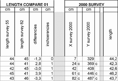
5.6.7 Survey comparing: extrados of 1955 and 1982 - extrados survey 2000 and verifies Being the 1955 survey without global dimensions, for what concern the extrados curves of the bridge archivolt, it was only possible to perform the comparing of the local lengths of the 1955 survey with the calculated lengths of the 1982 survey. Nevertheless, as it has been already exposed, these are the most reliable dimensions of each survey.
fig.22 - A small portion of the chart related to the first compare and to the 2000 survey - north elevation The chart is here next detailed explained:
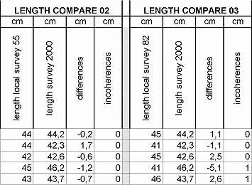
The "2000 survey" is the conventional name here given for the geometry of "the most likely bridge of Mostar" worked out trough the described procedures. The 2000 survey is a virtual survey that derives from the analysis and the study of the available data. The 2000 survey has been worked out following the same procedure and same criteria adopted for the intrados and described at §5.6.5. The 2000 survey is at the same time the last step and the result of the numerical analysis, and the first step towards the design layout; this also because the structural calculation progression has confirmed that there is no need of making changes to the bridge geometry most likely layout. In the extrados curves there is an exception to the above statement since the ends of the curves are not part of the survey 2000 but part of the design, and they have temporary worked out by prosecuting the archivolt shape until the springers. They may will be redefined after dismantle of the arch stones near by the springers or may be even not investigated if the dismantle will not be necessary. Another compare has been made to check how the final situation was related to the ancient survey best data, and this has been done either for the stones lengths, either for the X,Y co-ordinates of the 1982 surveys, as showed in the following samples of the charts.
fig.23 - A small portion of the comparing among 2000 survey and ancient data - north elevation
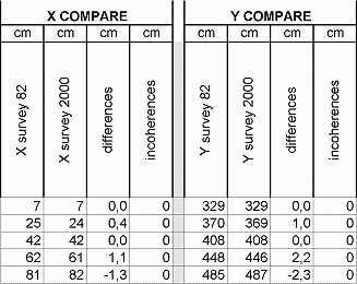
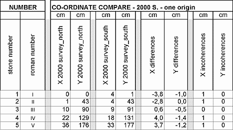
fig.24 - A small portion of the comparing among 2000 and 1982 survey co-ordinates - north elevation The 2000 survey is therefore numerically defined also for what concern the extrados lines of the north and south side.
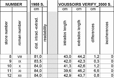
5.6.8 2000 survey checks: intrados and extrados comparing charts Intrados and extrados length of every single voussoir have been monitored in a special chart, this because, being very much alike one to each other, it was necessary to check that no intrados length was higher than the extrados length, to ensure a correct functioning of the arch structure. Moreover all the data concerning the distance among intrados and extrados of every single arch stone, coming from the 1955 survey, have been filed in the same chart which is supposed to report all the information concerning the relationship between intrados and extrados curves. Here next is reported a sample of the chart and the explanation of every single column:
fig.25 - A small portion of the comparing among intrados and extrados data plus the 1955 survey distances - north elevation Results coming from this chart have been encouraging since only a few data had to be checked, and for differences not lower than cm -1.
5.6.9 2000 survey checks: north-south comparing charts Another aspect that has been monitored is related to the differences among the two elevations of the bridge. This has been performed by shifting all the co-ordinates of the south elevation to the origin of the north side. This way the X,Y co-ordinates may be compared for a better monitoring of the irregularities of the archivolt in its thickness.
fig.26 - A small portion of the comparing among north and south co-ordinates - intrados curve The above chart may be described as follows:
The results of this comparing chart is that there are remarkable differences among north and south side, which was expectable, since the north and south span are different and the archivolt stone layout coming from ancient surveys is characterised by a variable gradient of row joints. These differences mostly vary from 5 to 15 centimetres and only in one point they reach almost 20 centimetres. For what concern, instead, the lengths of homologous dimensions belonging to north and south side and related to the intrados and extrados curves, it may be said that there are not such remarkable differences as the ones monitored for the X,Y co-ordinates: the range is from 0.5 centimetres and 3.5 centimetres with only one case that goes up to 12 centimetres. Here next there is a sample of the above mentioned "check chart":
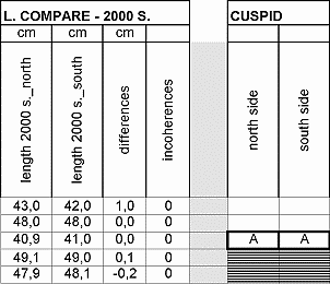
fig.27 - A small portion of the comparing among north and south lengths and of the cuspids - intrados curve
The columns of the cusps analysis (north side and south side) is aimed at a simultaneous monitoring of the bridge curvature shapes, and represent the results coming from the centres inquiring mathematical routine (se also §5.9 of this report). On this subject it may be said that it is possible to find a relationship among south and north elevation concerning the number and the position of the cusps.
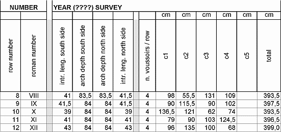
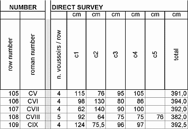
5.6.10 Numeric analysis chart for the archivolt For what concern the bridge archivolt it has been performed a similar numerical inquiry to the other bridge elements above described. This was mainly aimed at the determination of the stone dimensions in the thickness of the bridge, to allow the complete knowledge of the geometry of the load bearing vault. Among the ancient documentation, it was available, only for the present case, an additional survey of unknown origins given to General Engineering by the Conex company (that was supposed to collect part of the documents related to the previous condition of the bridge). This survey has got a fairly good readability, even if it is only a mosaic of different photocopies and may not be used as a graphical metrical reference but may be only remounted taking its written dimensions. The first part of the chart contains all the dimensions related to the above mentioned survey:
fig.28 - A small portion of the available data coming from an unknown survey – archivolt analysis The above chart may be here detailed explained:
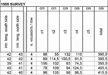
The same procedure followed in the above chart has been performed for what concern the 1955 survey, that is here next reported:
fig.29 - A small portion of the available data coming from the 1955 survey – archivolt analysis
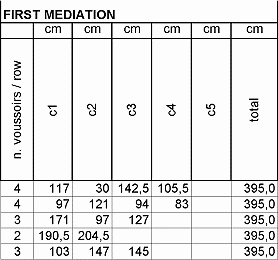
fig.30 - A small portion of the available data coming from the direct survey – archivolt analysis Ancient survey data have been then compared to the direct survey data, as it has been done for the intrados lengths during the numerical analysis of the curves. This is shown in the above chart that is structured in a similar way to the previous ones. The 1982 survey didn’t offer a valid support for this purpose, since the intrados view are mainly projections of the archivolt of a very low readability and where it mostly seems that some of the joint connections were not documented. The 1982 survey has been used, as in other occasion during this work, to gather the global dimensions: the bridge thickness, which has been evaluated to be almost constant, or at least, being the representation scale 1:50 it couldn’t be possible to determine any remarkable difference or variation along the whole vault. Being the available and listed data very much heterogeneous, it has been performed a first mediation among the different values, monitoring also the transversal joint shifts which is an important parameter to be checked to ensure a good functioning of the masonry structure.
fig.31 - A small portion of the first mediation on the archivolt data
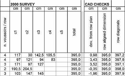
5.6.11 The 2000 survey and verifies – archivolt After that it could be possible to work out the most probable layout of the bridge intrados stone by stone, determining each stone thickness, which was the only unmonitored data of the intrados geometry: joints among arch stones rows may be worked out trough the intrados points. The survey 2000 of the stone joints is here next sampled in the following chart:
fig.32 - A small portion of the survey 2000 chart for the archivolt joints and the verify chart The above chart is organised as the previous ones and the columns have the same meaning. This constitutes actually a remarkable result because, even if it has been worked out from ancient surveys of scarce graphical quality, it has been checked with some recovered blocks of assembled stones that completely match the above metric data. Other checks have been performed directly in the 3d graphic model of the archivolt carried out in a CAD system. Those checks are mostly aimed at the stone cut executive design and will be commented subsequently, anyhow it can be anticipated what follows:
|
|
|
CREDITS: Intellectual property of this report and of the design drawings is owned by General Engineering s.r.l.author of the text: arch. Manfredo Romeo – other contributes have been mentioned in related paragraphs © - General Engineering Workgroup - SOURCE: Final Design Report |
|