| PRELIMINARY TECHNICAL CHECKS and PROPOSALS section #2 | English
|
||
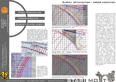
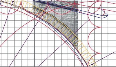
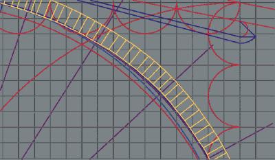
SURVEY OPTIMIZATION - ERROR MEDIATION The work done for the bridge survey determination has been towards the filing of all the metric sources in only one informatic system that allows the graphical and numerical comparison of all the data. Through this operating method it has been possible to locate anomalies and errors of the data sources. All the choices made have been documented trough data tables and graphic representations: any of the requested elaboration will be provided as it is, and with the documented differences with the other data sources. Moreover the result of this job will lead to the working out of a single survey of the bridge which is the most probable survey (with the available data) of the Stari Most as it was before destruction. This survey will constitute the first step towards a complete three dimensional model of the arc, and the first step towards the restoration design with the possibility of giving the exact geometry location and dimensions of every single stone of the bridge to be found from the river or to be substituted or integrated as lack or gap.
Main elaboration - north elevation - comparison phase with data sources coming from the survey of the 1980.
Main elaboration - north elevation - comparison phase with data sources coming from processed images trough electronic photogrammetry informatic systems
Main elaboration - north elevation - comparison phase with data sources coming from numerical data of the survey of the 1950
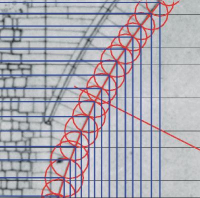
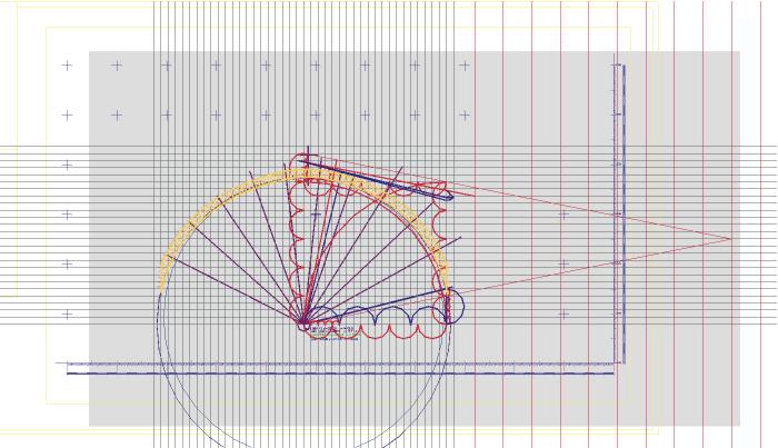
Main elaboration - north elevation - all the numerical local data has been represented with circles of radius equal to the corresponding value, before setting final position in x,y.
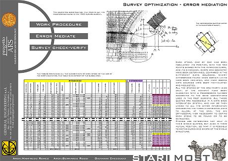
Main elaboration - north elevation - differences found on to data coming from different sources: the correction will be done trough a rotation of the intrados point on to a circle of radius equal to the numerical local data of the 1950 survey but keeping the height coming from the 1980 survey. This because global measures are more reliable in photogrammetric surveys. Any variation has been documented and verified on other data sources. Each stone, one by one has been filed: its position,
with the two points shared with the intrados curve, and its dimension, shape and geometry
have been determined, compared in the different data sources. Every differences found over
certain limits have been mediated, and many wrong data sources have been located and
neglected.
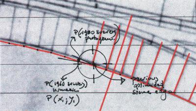
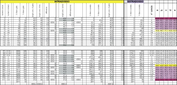
The tables containing all the numeric data of each stone of the arc of the north elevation. The table Is an extract of the global one.
The references dimensions listed in the electronic sheet.
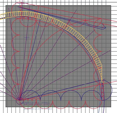
The geometric construction that points out the incoherence found in the 1950 numeric survey.
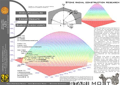
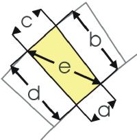
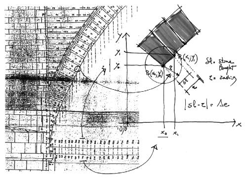
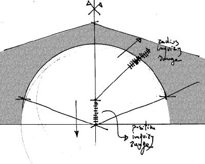
STONE RADIAL CONSTRUCTION RESEARCH One of the most significant impediment found in the
layout of the vectorial drawing of the survey has been the stone connection orientation:
small differences found in intrados and extrados length, or simply the thickness of the
representation lines in the photogrammetric survey may lead to a considerably high error
on the local stone gradient. This may bring to a general discordance in the final layout
of stone radial directions.
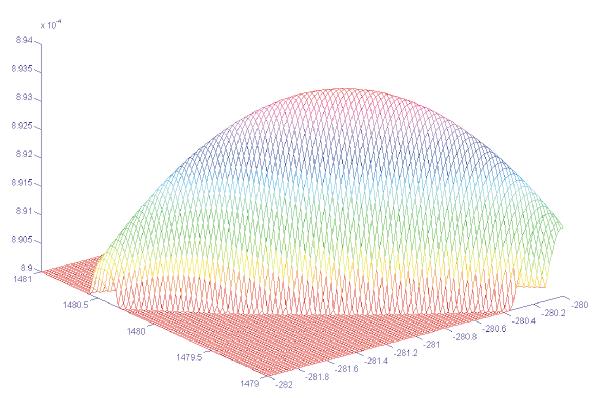
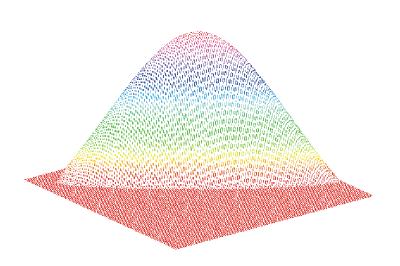
Last step graphic, representing in X, the center position by the middle point of the arc span, in Y the radius value, and in Z the minimum error found comparing all the intrados points of the arc in the right part of north elevation (not affected by settlements and deformations).
Ranges in which radius and center position should vary in the seek of the best-fit.
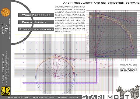
ARSIN MODULARITY AND CONSTRUCTION COMPARE The Arsin modularity constitutes a fundamental parameter with which should be compared the mathematic and geometric model to understand wether the construction is correct or not. The Arsin measure is not sharp, and varies in a certain range documented by historic researches. This investigation was first led by Prof.Arch.Blasi, and from this indication the work has been developed to verify data obtained trough the mathematic analysis. The results are reliable, and in the historic range of the Arsin the geometric construction of the bridge may be compatible.
Preview of the global drawings of the north elevation: they will be printed in a scale of 1:50 with all the dimensions of every single stone, in a table of 1.5×1 meters |
|||
| author of the text: arch. Manfredo Romeo; arch. Bernardo Rossi; tech. Giovanni Checcucci | |||