| Preface In the year 1999, when still everything was very
much undefined about the reconstruction design, General Engineering was asked to provide
preliminary technical documentation about the studies that could be worked out for the Old
Bridge of Mostar.
On that occasion some tentatives were
performed although the source data available were still very scarce and not in final
formats.
The results and comments are contained in
the following technical report: of course most of the contents are not anymore
updated any many things are innacurate, but this report let us understand, on one side,
how difficult it was to start a work of the kind, and on the other, how many design
strategies were correctly started from the very beginning.
By the right side there are some pages of
the report in its original layout.
Preliminary studies for the Old Bridge have been
developed by General Engineering during the years 1996-1999 on its own, with no help, few
data and no resources.
Authors of the text: Manfredo Romeo -
Bernardo Rossi - Giovanni Checcucci.
In this first part of the document there are the
following paragraphs:
introduction - working procedure
available data sources analysis
|
|
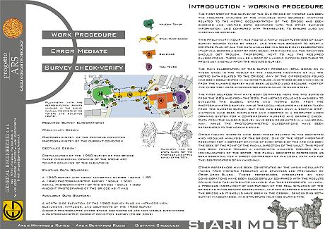
INTRODUCTION - WORKING PROCEDURE
Required Survey Elaborations:
Preliminary Design:
Photogrammetry of the previous condition
Photogrammetry of the current condition
Dectailed Design:
Digitalization of the 1950 survey of the bridge
Three dimensional drawing of the stone arc
Tematic drawings of the elevations
Existing Data Sources:
A 1950 survey with local numerical dimensions - scale 1:50
A 1980 photogrammetric survey - scale 1:200
Aerial photogrammetry of the bridge - scale 1:200
Ancient Photographs of the bridge as it was
Available Data Sources:
A north side elevation of the 1950 survey plus an intrados view.
Elevations, intrados, and abutments of the 1980 survey
Ancient photographs where stone connections are not visible everywhere
A photogrammetric current condition survey (to be completed)
Planimetry with the representation fronts
involved in the survey plus all the others of the towers and buildings near by.
The first step of the survey of the Old Bridge of
Mostar has been the accurate analysis of the available data sources: anything related to
the metric documentation of the Bridge has been checked and verified both compared with
the other surveys information, and compared with themselves, to ensure also an internal
coherence.
This preliminary inquiry has found a fairly incompleteness of each survey source taken by
itself, and this has brought to start a compare plan of all the data available in a single
main elaboration, (that will become a sort of data base), from which all the drawings
should get trough. Therefore, next to all the required elaborations, there will be a sort
of numeric differences table to prove any anomaly from the mediated survey.
The main elaboration of this survey program, is the result of the accurate mediation of
all the metric data related to the Bridge. Any of the differences found has been
documented in numeric tables, and those ones which came from the numeric survey have been
located also because, most of the times they were among other data similar to each other.
The first sources that have been compared were the two surveys from the '50's and from the
'80's. The method followed has been to evaluate the global shape and metric data from the
photogrammetric survey, while the local measures have been taken from the numeric survey,
but this has been only a staring step: anything have been digitalized and inserted in a
computer aided drawing system for a contemporary numeric and graphic check. Data from the
numeric survey have been remounted in a numerical way, while the photogrammetric
elaborations have been referenced to the working scale.
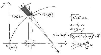
Other inquiry systems have been those related to the geometric and modular analysis of the
bridge. One of the most important research for a correct drawing of each stone of the arc
has been the seek of the point of the radial direction of the vault. This point has been
found trough a mathematic analysis focused on a minimalization of the error, the radial
geometric references as been essential for a direct comparison of the local data and for
the identification of any anomaly.
Other references have been constituted by the arsin modularity (taken from historic
research and drawings led previously by Prof.Arch.Blasi). These references integrated by
new considerations have been successfully compared with the results coming from the
mathematic analysis. All this represents, anyhow, a precious instrument of comparison of
the real situation of the bridge as it was before destruction, and the supposed geometry
of the bridge as it should have been in the design, denouncing both survey inaccuracies,
and structure yeldings during time.
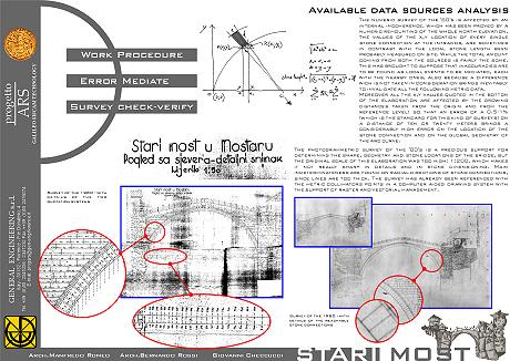
Planimetry with the shots taken for the
photogrammetric survey of the ‘80’s.
AVAILABLE DATA SOURCES ANALYSIS
The numeric survey of the '50's is affected by an
internal incoherence, which has been proved by a numeric remounting of the whole north
elevation. The values of the x,y location of every single stone connection at the
intrados, are sometimes in contrast with the local stone length been probably measured on
site. While the total amount coming from both the sources is fairly the some. This has
brought to suppose that inaccuracies are to be found as local events to be mediated, each
with the nearby ones, also because a difference wich is not taken in consideration brings
inevitably to invalidate all the following metric data.
Moreover all the x,y values dimensioned in the botton of the elaboration are affected by
the growing distances taken from the origin and from the reference level: so that an error
of a 0.5-1% (which is the standard for this kind of surveys) on a distance of ten or
twenty meters brings a considerably high error on the location of the stone connection and
on the global geometry of the arc curve.
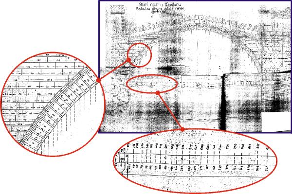
Survey of the 1950 - with details of the two
dimensioning systems
The photogrammetric survey of the '80's is a
precious support for determining the shape, geometry and stone locations of the bridge,
but the original scale of this elaboration was too high: 1:200, which makes it not really
sharp in details and in stone dimensioning. Main indeterminateness are found on radial
directions of stone connections, since lines are too thick. The survey has already been
referenced with the metric collimators points in a computer aided drawing system with the
support of raster and vectorial management.
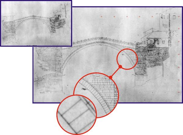
Survey of the 1980 - with details of the
reachable stone connections
The photogrammetric survey trough the use of ancient
pictures of the bridge is one of the most important data source since it is the only one
which allows current surveys with known errors and methods on a structure that doesn't
exist anymore.
Nevertheless the sharpness of those elaborations are related to the quality of the source
photographic shoots: the ones available are fairly good, but in many areas stone
connections are not visible, and vegetation sometimes covers important areas.
Anyway other photo documentation of better quality may be found in the next future, and in
any case these data sources have to be connected to the control points on the ruined parts
of the arc (see next).
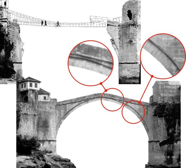
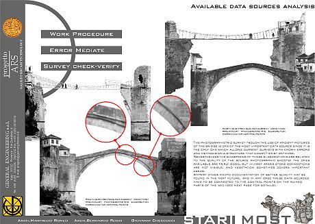
South side previous and current condition:
preliminary photogrammetric elaboration worked out on control points
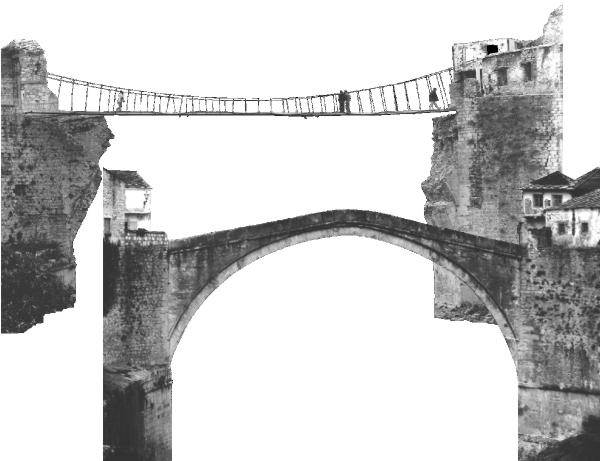
North side previous and current condition:
preliminary photogrammetric elaboration worked out on control points
Control points are necessary to connect the survey
in its global geometry, and are used both to verify the existing surveys, and to work out
new elaboration of the ancient photo documentation.
Trough the use of these points taken on the ruined parts of the elevations of the bridge
(even if they are really small parts), it is possible to obtain useful orthogonazilations
of the elevations of the bridge. Moreover, the points are taken in x,y,z coordinates and
they are precious for any 3d elaboration, or for relating elevations one to the others, or
for determining projection elements.
Some of these points have already been surveyed, and they have been transformed trough
rototraslation to locate the plan of the north and south side of the bridge, and for
proceeding to the photogrammetric rectification of the elevations.
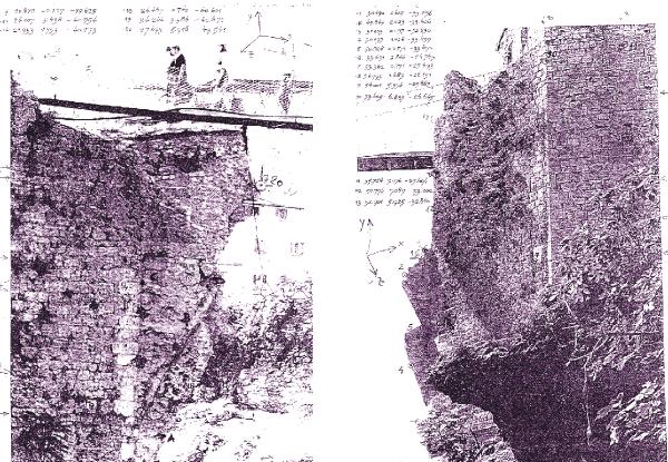
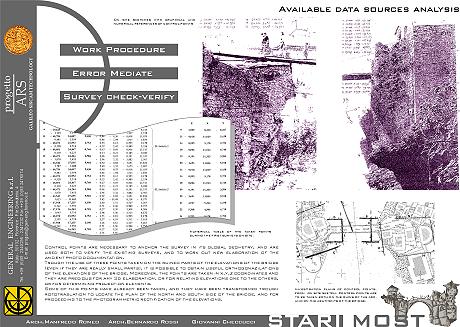
On site sketches with graphical and numerical
references of control points
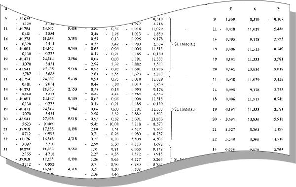
Numerical table of the taken points during
the first surveys on site.
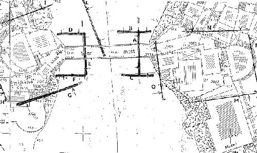
Investigation plans of control points, from
on site sketch. Control points are to be taken both on the ruins of the arc, and on the
abutments of the bridge.
|